- Physics Lab Equipment
- Chemistry Lab Equipment
- Biology Lab Equipment
- Anatomical Lab Equipment
- Learning
- Educational Lab Equipment
- Magnets
- Agriculture
- Astronomy
- Earth Science
- Geography Lab Equipment
- Safety Lab Coat
- Laboratory
- Meteorological
- Electricity & Magnetism
- Heat
- School Lab Equipment
- Lab Glassware
- Science Lab Equipment
- Tvet Lab Equipment
- Robotics Kits Supplier and Manufacturer for Schools India
- Math Lab Equipment Manufacturers and Exporters in Ambala
- STEM Kits Manufacturers and Supplier India
- Engineering Lab Equipment
- Hospital Lab Equipment
- Water, Sanitation & Hygiene Supplies
- Cold Chain, Solar & Communication Equipment
- Nutrition
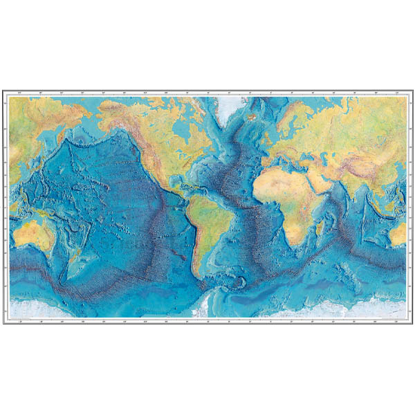
Ocean Floor Raised Relief Map
Ocean Floor Raised Relief Map (Product Code: SLE/GG/20) is a 660 x 990 mm raised relief map of the world that captures the geography of both the land and the ocean floor. Ridges, mountains, continental shelves, trenches, continental slopes and islands stand out in relief, so students can see and feel the shape of the seabed that a flat atlas page hides. Geography and earth science departments use it as a wall or table display for lessons on plate tectonics, oceans and landforms, and framing options are available. The map is manufactured by Jain Scientific Equipments Pvt Ltd (ScienceLab), Ambala.
Specifications
| Parameter | Detail |
|---|---|
| Coverage | World — land and ocean floor |
| Map type | Raised relief |
| Features depicted | Ridges, mountains, continental shelves, trenches, continental slopes and islands |
| Size | 660 x 990 mm |
| Framing | Framing options available |
Typical Use
The map is at its most useful when students trace features with their fingers: following a mid-ocean ridge across an ocean basin, then finding a deep trench beside a chain of islands or a mountain coast. That comparison opens up the idea of plates pulling apart at ridges and sinking at trenches, and explains why earthquakes and volcanoes cluster where they do. Continental shelves and slopes give a clear picture of where the land really ends and the deep ocean begins.
Teachers also use the map for quizzes on ocean names and island groups, and alongside a flat political map to show how much of Earth’s relief lies under water. The tactile surface helps learners who understand shapes best by touch. Like any piece of geography lab equipment, it lasts longer when dusted with a soft, dry brush, kept out of strong direct sunlight and protected from heavy pressure on the raised areas.
Manufacturer
Jain Scientific Equipments Private Limited, known to customers as ScienceLab, produces relief maps and other geography models in Ambala, Haryana. The company supplies schools, colleges and education distributors in India and international markets. Our company profile explains more about ScienceLab.
Related Geography Lab Equipment
Use these items with the Ocean Floor Raised Relief Map for a complete landforms and tectonics unit:
- Landform Relief Maps — relief maps focused on land features and topography.
- Physiographic Relief Globe — shows relief on a globe to avoid map distortion.
- Seismograph Model — links the plate boundaries on the map to how earthquakes are measured.
- Volcano Model — explains the volcanic islands and mountains marked on the map.
Browse further in Geography Lab Equipment.
Frequently Asked Questions
What size is the map?
It measures 660 x 990 mm.
Which ocean-floor features are shown?
Ridges, trenches, continental shelves and continental slopes, along with mountains and islands on land and at sea.
Is the map supplied framed?
Framing options are available. Tell us whether you need a framed or unframed map when you enquire through the contact page.
What material is it made from?
The material is not listed on this page. Please ask our team for construction details before ordering.
How should the map be cleaned?
Dust it gently with a soft, dry brush or cloth. Avoid solvents and do not press hard on the raised relief.
Can you supply maps for several classrooms or export customers?
Yes. ScienceLab quotes for multiple units and ships to institutions in India and international markets.
Request a Quote
Ask for a quotation on the Ocean Floor Raised Relief Map, framed or unframed, through our contact page, or add it to the enquiry cart.
Last updated: 24 September 2026